
What Szigliget and the Witness Hills of the Surrounding Region Tell Us
JÓZSEF SZÁSZI (geometodika.hu)
Lakeside Secondary School and Vocational School of Arts, Székesfehérvár; Ez az e-mail-cím a szpemrobotok elleni védelem alatt áll. Megtekintéséhez engedélyeznie kell a JavaScript használatát.
Introduction
Who has not visited Szigliget, studied it, or at least heard of the Castle of Szigliget? My native village, Szigliget, and its surroundings in the Tapolca Basin are among the most beautiful excursion and holiday destinations in Hungary. Its favourable geographical location, geological and botanical treasures, historical monuments, folk architectural heritage, castle ruins, and last but not least the excellent wines of the Badacsony Wine Region provide unforgettable experiences for both domestic and international visitors. Unfortunately, most travellers merely “rush through” this remarkable landscape, “run up” to the castle, take a quick dip in Lake Balaton, and continue on their way.
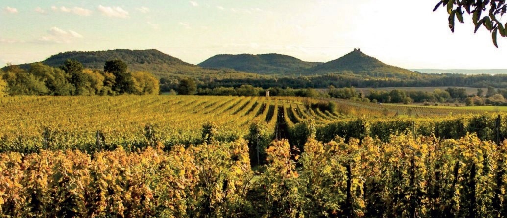
Throughout my thirty-nine-year teaching career, I have brought countless students here from Székesfehérvár on school excursions. As a form teacher, I regularly chose Szigliget and the surrounding witness hills (Badacsony, Saint George Hill and Csobánc) as both the first and often the final class trip destination for my students. Together with colleagues, I also organised several forest school programmes in Szigliget. In both my educational and popular science activities, I have always sought to help visitors hear and better understand what Szigliget has to tell. I undertook the writing of this study partly to draw the attention of fellow educators to the natural and cultural values of this landscape and to demonstrate how effectively the region can be incorporated into both classroom and extracurricular teaching at primary and secondary school levels. I also hope that this article will help readers refresh their previous knowledge of the Tapolca Basin and become acquainted with more recent scientific findings.
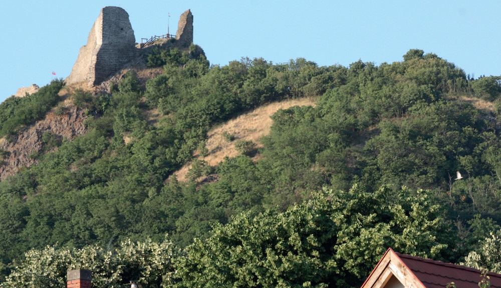
As an invitation to explore Szigliget and the surrounding witness hills in greater depth, I would like to quote from the 1982 edition of Travels Around Lake Balaton (1900) by Károly Eötvös. This book, one of the defining literary experiences of my youth, is at once a collection of anecdotes, a history book, and a travel guide. In its chapter entitled The Most Beautiful Region in the World, we find the following lines: “Before me rise the wooded peaks of Szigliget. Small peaks indeed. Yet upon one stands the ruin of an ancient castle, a mass of broken walls, crumbling towers, and roofless corridors. The ruin stands there like a decayed crown upon the head of an old king. Through the openings of doors and windows shines the sunlight, and from afar that light appears like precious jewels adorning the crown.” (p. 383).
What the Landscape Tells Us
The Tapolca Basin is one of Hungary’s best-known and most thoroughly studied geographical micro-regions. Since the scientific literature on this area is exceptionally rich, I shall mention only the most important geological and geographical researchers. The earliest descriptions were written by the French geologist F. S. Beudant (1822), while among the early publications the work of I. Vitális (1911) deserves special mention. Later, a monograph series unique even by European standards was published under the title Results of the Scientific Study of Lake Balaton. Lajos Lóczy, author of the volume The Physical Geography of Lake Balaton and Its Surroundings, wrote: “The other major basalt tuff and basalt flows are concentrated along the geomorphological axis of the Balaton Uplands; these include the plateaus near Egervölgy, as well as Tóti Hill, Gulács, Badacsony, and Saint George Hill.” (Lóczy, 1913, p. 422). A leading researcher of basalt volcanism was L. Jugovics (1944, 1968). Later, my thesis supervisor, Zoltán Borsy, contributed important new data to the geological history of the Tapolca Basin (Borsy et al. 1986). The results of landscape-geographical research were subsequently summarised in the relevant chapter of Volume 5 of the series The Regional Geography of Hungary (Pécsi, 1987).
While writing this article, I realised that scientific interest in this region has not diminished since the completion of my two theses (Szászi, 1983, 1985); on the contrary, significant discoveries have been made in recent decades. These new geological findings have fundamentally transformed our scientific understanding of the evolutionary history of the monogenetic phreatomagmatic basalt volcanoes of the Balaton Uplands and the Tapolca Basin. In this field, Károly Németh and his colleagues played a pioneering role (Németh et al. 2000, 2003; Martin & Németh 2004, 2012). Particularly valuable new insights have also been provided by Barnabás Korbély concerning the phreatomagmatic pyroclastics of Szigliget and by Mátyás Hencz regarding those of Badacsony (Korbély et al. 2000; Hencz et al. 2017).
The Badacsony Landscape Protection Area was established in 1965, becoming the second such protected area after Tihany. Its territory gradually expanded to include the southern part of the Tapolca Basin as well as the volcanic witness hills of Gulács, Tóti Hill, Csobánc and the Szigliget Tuff Group. Since 1997, the region has enjoyed Hungary’s highest level of nature protection as part of the Balaton Uplands National Park, which incorporated the former protected landscape area. The region also forms part of the Bakony–Balaton Geopark, established and maintained by the National Park Directorate since 2012. Through personal experience, I have witnessed how the enthusiastic professional work of János Futó and his colleagues has been indispensable in promoting awareness of the area’s geological heritage (Futó, 2003), supporting geoscience education, and developing geotourism. I would also like to highlight the work of Barnabás Korbély (2005), who wrote:
“The hills of Szigliget gently interrupt the marshy meadows surrounding the internationally renowned ‘classical’ witness hills of the Tapolca Basin, namely Badacsony and Saint George Hill. The village itself is one of the few lakeside resorts where the Old Village, with its narrow winding streets and restored peasant houses, has preserved the beauty worthy of a landscape inhabited for centuries.”
It is no coincidence that one of the most beautiful sections of Hungary’s National Blue Trail, between Tapolca, Saint George Hill and Badacsony, passes through Szigliget. Furthermore, in 2005 the Kamon-kő Nature Trail was established, beginning and ending at the foot of Castle Hill. Visitors who complete this six-kilometre educational trail, marked with a blue “T”, can discover the protected natural features of Szigliget, both living and non-living, as well as its historical monuments and surviving examples of vernacular architecture.

What the Volcanoes Tell Us
The history of the Tapolca Basin began during the Neogene period of geological time (Balogh et al. 1982; Wijbrans et al. 2007). At that time, much of the Carpathian Basin was covered by the Pannonian Inland Sea, later known as Lake Pannon. Rising above its waters as islands and peninsulas stood the hills of the Transdanubian Central Range, a geological unit with a particularly complex evolutionary history.
The large-scale structure of this geological region, composed of repeatedly folded and thrust Palaeozoic and Mesozoic rock masses, was fragmented by Neogene tectonic movements into a series of horsts and intermontane basins, creating a so-called “Basin and Range” type landscape (Juhász, 1999). One of these tectonically subsided southern embayments occupied the area of the present-day Tapolca Basin.
By the end of the Miocene Epoch, the former Pannonian Inland Sea maintained only a narrow connection with the world ocean. Once this connection closed, the inland sea gradually transformed into a vast brackish lake that slowly became freshwater. Subsequently, ancient rivers flowing into the basin—most notably the Proto-Danube and Proto-Tisza—filled Lake Pannon with sediments. As a result, several hundred metres of Pannonian deposits, including sandstone and siltstone, accumulated over the older rocks that formed the floor of the former bay (Jámbor et al. 1981).
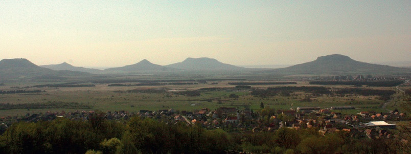
Approximately eight million years ago, significant basaltic volcanic activity began in the Transdanubian Central Range (Wijbrans et al. 2007). Through a succession of volcanic eruptions, an extensive volcanic field developed across the Bakony Mountains, the Balaton Uplands, the Tapolca Basin and the Keszthely Hills.
The volcanoes of Szigliget differ from most volcanic witness hills of the Tapolca Basin in both geological and geomorphological terms (Szászi 1983, 1985, 1997). Most of the neighbouring witness hills consist predominantly of basaltic lava rock, whereas Szigliget is composed mainly of basaltic tuff and other pyroclastic deposits associated with explosive volcanic eruptions.
There are also important geomorphological differences. The surrounding witness hills are cone-shaped (Gulács and Tóti Hill), truncated cones (Badacsony and Csobánc), or tent-shaped formations (Saint George Hill). In contrast, the Szigliget Tuff Group consists not only of the irregular cone of Castle Hill (Vár-hegy), but also of two additional volcanic witness hill complexes—the Antal Hill Tuff Group and the Outer Hill Tuff Group—both of which form deeply dissected truncated cones (Jugovics 1944, 1968; Szászi 1983, 1997).
What the Witness Hills Bear Witness To
Today, the classical theory explaining the formation of witness hills is considered outdated. According to this earlier interpretation, the solidified mass of basaltic volcanic rock protected the former land surface from erosion. Consequently, the elevation of the Pannonian sedimentary layers preserved beneath the volcanic rocks was thought to “bear witness” to the altitude of the ancient surface upon which the volcanic material had originally been deposited (Cholnoky 1936; Jugovics 1968).
In 1982, while collecting basalt samples from the witness hills of the Tapolca Basin for my university thesis, I had the opportunity to obtain radiometric age data produced by the Institute for Nuclear Research (ATOMKI) in Debrecen through the courtesy of physicist Kadosa Balogh, who led the dating programme (Balogh 1982).
According to both the original and more recent K/Ar and 40Ar/39Ar radiometric measurements, the basalt and basalt-tuff rocks of the volcanic witness hills of the Tapolca Basin were formed between approximately 4.72 ± 0.04 million years ago (Tóti Hill; Wijbrans et al. 2017) and 2.94 ± 0.33 million years ago (Haláp; Balogh 1982; Borsy et al. 1986; Martin & Németh 2004).
The radiometric ages of the principal witness hills discussed in this study are as follows: Tóti Hill – 4.72 ± 0.04 million years; Outer Hill Tuff Group of Szigliget – 4.12 ± 0.12 million years; Csobánc – approximately 3.42–3.50 ± 0.41 million years; Antal Hill Tuff Group of Szigliget – 3.37 ± 0.70 million years; Saint George Hill – approximately 3.21–3.50 ± 0.04 million years; Gulács – 3.47 ± 0.18 million years; Badacsony – 3.45 ± 0.23 million years; and Castle Hill of Szigliget – 3.41 ± 0.13 million years.
Borsy and his colleagues (1986) were among the first to point out that the 40Ar/39Ar radiometric age data could not be reconciled with the previously accepted assumption that the oldest witness hills were those whose underlying Pannonian sedimentary layers occur at the highest elevations above sea level.
As a result of more recent research, we now interpret the formation of the basalt witness hills of the Tapolca Basin in a fundamentally different way. The volcanic eruptions of the Bakony–Balaton Uplands Volcanic Field were predominantly characterised by phreatomagmatic explosive activity. This means that ascending magma came into contact with water-rich sediments, triggering violent explosions (Németh & Martin 2004; Hencz et al. 2017).
Depending on the depth of these explosions and the ratio between water and magma, different volcanic landforms developed. Every volcanic centre began with an explosive phase dominated by the violent release of steam and volcanic gases. During this stage, fragmented volcanic material known as pyroclasts was produced.
Deep-seated explosions formed crater-like depressions known as maars, whereas shallower explosions produced small positive landforms called tuff rings. During the second stage of volcanic activity, one or more lava flows filled these craters and subsequently solidified into thick basalt caps. In some locations, including Tóti Hill and Gulács, relatively small basalt caps developed, while at Csobánc the basalt cover became much more extensive.
Elsewhere, repeated lava outpourings filled the tuff ring or maar with a large lava lake. After cooling, these lava lakes solidified into broad basalt plateaus, or basalt mesas, such as those found at Badacsony and Saint George Hill. In the case of Tóti Hill, Gulács and Csobánc, volcanic activity ceased after one or several lava flows had occurred (Martin & Németh 2004).
Saint George Hill followed a somewhat different evolutionary path. Earlier researchers, including Jugovics (1968), interpreted it as a stratovolcano. Modern studies, however, indicate that it too originated as a monogenetic phreatomagmatic maar or possibly a tuff-ring volcano (Martin & Németh 2004).
As with the other witness hills, the initial explosive phase produced abundant pyroclastic material, after which the maar or tuff ring became filled by a lava lake. Subsequently, renewed explosive activity deposited additional pyroclastic layers. During the final stage, further lava outpourings occurred. The upper pyroclastic layer contains basalt bombs of various sizes, locally known as bread stones (kenyérkő) (Jugovics 1968; Szászi 1983, 1997).
Badacsony is among the best-studied volcanoes of the region. Similar to Saint George Hill, its formation can be explained by the development of a monogenetic phreatomagmatic maar or, possibly, a tuff-ring volcano (Martin & Németh 2004; Hencz et al. 2017). Remarkably, the first two volcanic stages and the final post-volcanic stage of Badacsony show interesting parallels with the formation of the Szigliget Tuff Group.
According to Hencz et al. (2017), the volcanic and post-volcanic evolution of Badacsony can be divided into five principal stages. During the active volcanic phases, both explosive eruptions and lava effusions produced not only pyroclastic deposits but also dense grey and reddish vesicular basalts (Jugovics 1968; Szászi 1983, 1997; Hencz et al. 2017).
Stage 1. Like the other witness hills, Badacsony began with the formation of pyroclastic deposits generated by volcanic explosions. During the initial phase, ascending magma intruded into near-surface fluvial and lacustrine sedimentary layers. These Pannonian sediments, consisting primarily of fine-grained siltstones and sandstones, contained sufficient groundwater to trigger powerful phreatomagmatic eruptions (Németh et al. 2003).
During these violent eruptions, pyroclastic density currents deposited poorly sorted pyroclastic material while additional tephra was dispersed through the air. Based on the characteristics of these deposits, two interpretations appear most likely: the formation of a tuff-ring volcano, although the development of a maar volcano in a soft substrate cannot be excluded, as comparable examples are known worldwide.
Stage 2. The appearance of a different type of pyroclastic deposit indicates decreasing fragmentation and progressively “drier” eruption conditions. This suggests a shift in the water-to-magma ratio and the increasing dominance of purely magmatic explosive eruptions.
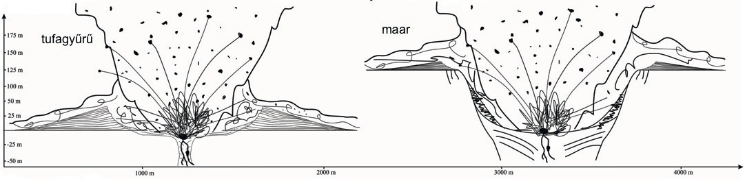
Stage 3. This was followed by Hawaiian-type lava effusion, as groundwater supplies were no longer sufficient to sustain phreatomagmatic activity. This change may have resulted from a significant reduction in groundwater reserves, an increased magma supply, or a higher magma ascent rate. The present circular morphology of the basalt body suggests that these lava flows remained largely confined within the crater, filling it and perhaps forming a small lava lake (Hencz et al. 2017).
Stage 4. Evidence from the overlying scoria deposits indicates that the volcano briefly returned to explosive activity. This time, however, it was characterised by purely magmatic eruptions of the Strombolian type, resulting in the construction of a scoria cone on the summit. Field observations suggest that remnants of this scoria cone are preserved mainly on the northern side of the mountain (Martin & Németh 2004; Hencz et al. 2017).
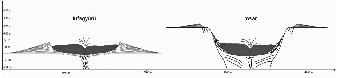
Stage 5. After volcanic activity had ceased, the mountain entered its post-volcanic erosional phase, during which the modern witness hill gradually took shape. The extent of erosion depended on whether the original volcanic landform had been a tuff ring or a shallow maar. A tuff ring would have required relatively limited erosion to reach its present form, whereas a maar volcano would have undergone much more extensive denudation (Hencz et al. 2017).
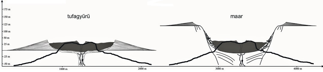
In summary, following the cessation of volcanic activity in the Tapolca Basin, a long period of erosion and denudation began. Although many of the volcanoes originally formed only relatively small positive landforms such as tuff rings—or, in some cases, crater depressions extending below the former land surface (maars)—the lava that accumulated within their craters during the later stages of volcanic activity protected both the volcanic deposits and the softer Pannonian sediments beneath them from substantial erosion.
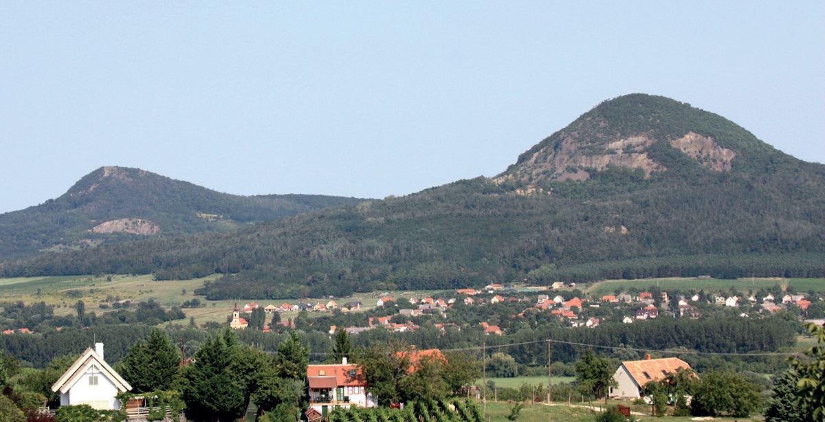
As a result, the relative height of the witness hills remained largely unchanged and may even have increased locally, since the resistant volcanic rocks eroded more slowly than the surrounding sediments. Within the volcanic structures themselves, however, those parts of the tuff rings not protected by basalt lava were removed most rapidly. Depending on the extent of the lava cover, erosion eventually produced either cone-shaped or truncated-cone witness hills. Gulács and Tóti Hill exemplify the former, while Badacsony and Csobánc represent the latter type.
What the Witness Hills of the Szigliget Tuff Group Tell Us
Before discussing the volcanic history of Szigliget, it is necessary to clarify the terminology surrounding volcanic tuff and pyroclastic material. Earlier geological literature commonly used the term tuff for volcanic fragmental rocks (Jugovics 1944, 1968; Szászi 1983, 1997; Borsy et al. 1986).
Today, both Hungarian and international volcanological literature generally follow the interpretation summarised by Dávid Karátson (1999): the term tuff refers to a specific grain-size category of pyroclastic material, whereas the correct general term for fragmented volcanic ejecta, regardless of grain size, is pyroclast (from the Greek words pyro, meaning fire, and clast, meaning broken fragment).
The lithified equivalent of accumulated pyroclastic material is known as pyroclastic rock, or pyroclastite. Nevertheless, in accordance with established geological terminology, I continue to use the expressions “tuff ring” and “tuff group” where appropriate (Jugovics 1944, 1968; Szászi 1983, 1997; Borsy et al. 1986; Martin & Németh 2004; Hencz et al. 2017).
In my view (Szászi 1983, 1985, 1997), the Szigliget Tuff Group represents a distinct type of volcanic witness hill. Unlike neighbouring Badacsony, the explosive pyroclastic eruptions at Szigliget were not followed by significant lava effusion. Furthermore, from a geomorphological perspective, the area displays considerably greater diversity than the surrounding witness hills.
The tuff group consists of Castle Hill (Vár-hegy), the Antal Hill Tuff Group and the Outer Hill Tuff Group. During subsequent erosion, the latter two complexes became fragmented into a series of smaller and larger pyroclastic remnants. The Antal Hill Group includes Antal Hill, Old Forest (Öreg-erdő) and Little Forest (Kis-erdő), while the Outer Hill Group comprises Inner Hill (Belső-hegy), Kamon-kő, May Day Hill (Majális-domb), Soponya, Óvár and Rókarántó (Szászi 1983, 1997; Borsy et al. 1986).
According to the first radiometric age determinations published by Balogh (1982), volcanic activity at Szigliget occurred in three separate phases. K/Ar and 40Ar/39Ar dating yielded ages of 4.12 ± 0.12 million years for the Outer Hill Tuff Group, 3.37 ± 0.70 million years for the Antal Hill Tuff Group, and 3.41 ± 0.13 million years for Castle Hill (Balogh 1982; Szászi 1983, 1997; Borsy et al. 1986).
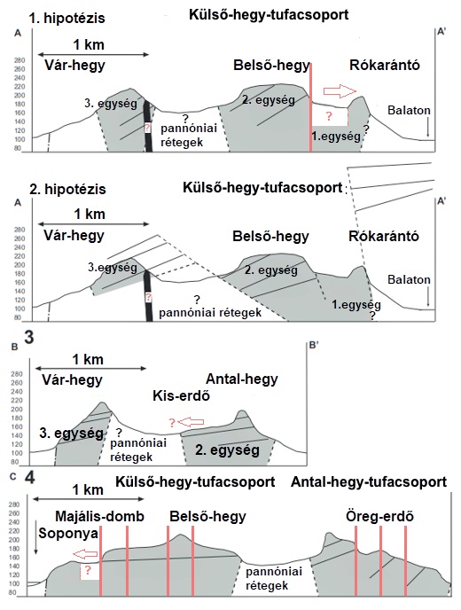
However, according to Németh et al. (2000), the pyroclastic layers of all three major volcanic remnants dip towards the northwest and exhibit very similar textures and compositional characteristics. This suggests that they may have formed as parts of a single complex but interconnected volcanic system. The entire pyroclastic succession of Szigliget was most likely produced by subsurface phreatomagmatic eruptions, and the resulting deposits can be grouped into three principal stratigraphic units (Németh et al. 2000).
The volcanic eruption was highly explosive. During the phreatomagmatic, Surtseyan-type eruption, erupting gases and steam carried vast quantities of rock fragments from older formations beneath the Pannonian sedimentary layers (Németh et al. 2000, 2003; Hencz et al. 2017). The pyroclastic sequence formed during the eruption was deposited within the crater ring of an earlier maar volcano, which later subsided toward the volcanic vent. Accordingly, Unit 1 represents the sediment filling this volcanic conduit, known as a “diatreme,” while Units 2 and 3 are products of pyroclastic fallout deposited close to the vent.
The lighter grey pyroclastic sequences of the Antal Hill Tuff Group and the Outer Hill Tuff Group (Units 1 and 2) are filled with fragments of Silurian phyllite, Permian red sandstone, and Triassic limestone and dolomite. These inclusions are known as xenoliths (literally “foreign rocks”), since they have no genetic relationship with the host rock. Particularly interesting is the fact that, besides crustal xenoliths, the Szigliget pyroclastic sequence also contains significant numbers of xenoliths derived from the Earth's upper mantle, some specimens reaching the size of a human head.
Based on their mineral composition, the upper mantle xenoliths of Szigliget (formerly known as olivine bombs) mainly belong to the peridotite rock family, including lherzolite (rich in olivine, orthopyroxene, and clinopyroxene) and harzburgite (rich in olivine and orthopyroxene) (Hidas et al. 2007). According to Jugovics (1944), a second volcanic phase followed, during which only limited lava flows succeeded the pyroclastic activity. Evidence of these flows survives in basalt debris preserved on the summits of Öreg-erdő and Belső-hegy.
During the post-volcanic phase, much of the pyroclastic sequence was eroded away. However, because it was more resistant than the underlying Pannonian sediments, it partially protected them from erosion. The erosional history of Szigliget differed from that of the other witness hills. During the Pleistocene, when tectonic subsidence formed the Balaton Basin, the tuff masses of the Antal Hill Group and Outer Hill Group broke into separate blocks (Jugovics 1944; Szászi 1983, 1997; Borsy et al. 1986; Németh et al. 2000).
Smaller and larger sections detached from the central pyroclastic mass of Belső-hegy and slid southwestward and southward toward the Balaton Basin along the eroding Pannonian slopes. These movements were caused by mass-wasting processes, including landslides, under the extreme tundra-like climatic conditions of the Ice Age. The larger detached pyroclastic masses protected parts of the Pannonian slopes from erosion, resulting in the secondary formation of four smaller witness hills: Majális Hill, Soponya, Óvár, and Rókarántó.
The most spectacular of these is Óvár, which evolved into an almost perfectly conical witness hill. Beneath its secondary tuff cap, the remnants of the Pannonian slope survive in a shape resembling a crinoline skirt. This feature gave rise to the hill’s popular name, “The Queen’s Skirt” (Gere et al. 2013), on whose summit the remains of a small medieval fortification can still be seen.
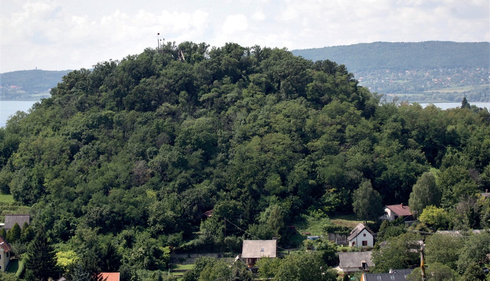
The younger, darker brown pyroclastic complex of Castle Hill (Vár-hegy) represents a volcanic phase that was distinct both spatially and temporally from the earlier eruptions (Jugovics 1944; Balogh 1982; Szászi 1983, 1997; Borsy et al. 1986). Here too, volcanic activity began with a phreatomagmatic explosion, although it was probably less violent. Fewer xenoliths were incorporated into the eruption products, and, according to current knowledge, upper mantle-derived rocks are entirely absent.
The later volcanic phases of Castle Hill were also predominantly explosive, destroying much of the volcano’s tuff ring (Németh et al. 2000). Molten lava rose through fractures associated with this process, much of it solidifying within the cracks themselves. This formed the narrow basalt dyke that cuts across the lower southern saddle of Castle Hill in an east–west direction. Following cooling, the dyke weathered into horizontally arranged basalt columns (Jugovics 1968; Szászi 1983, 1985, 1997; Borsy et al. 1986).
According to Németh et al. (2000), the relationship between Unit 3 of the Szigliget pyroclastic sequence and the other two units remains uncertain, and two hypotheses have been proposed. Based on the available evidence, both interpretations remain plausible.
Hypothesis 1: Unit 3 (Castle Hill) belongs to a completely independent volcanic vent system, later filled by the collapse and inward sliding of a series of earlier crater rings represented by Units 1 and 2.
Hypothesis 2: Units 1–2 and Unit 3 are components of a large and structurally complex volcanic conduit system, evidenced by the eroded volcanic structures visible today at Rókarántó and Castle Hill. In this interpretation, the conduit was filled by tilted and subsided crater-ring deposits that slid back into the vent, represented by Units 1 and 2, which consequently acquired a northwesterly dip. Units 1 and 2 are therefore closely related stratigraphically, while Unit 3 is interpreted as an early product of a large volcanic edifice.
During the post-volcanic phase, further erosion—similar to that which shaped neighbouring Badacsony—created the present appearance of Castle Hill, a 230.4-metre-high irregular witness hill with a cone-like profile (Jugovics 1968; Szászi 1983, 1985, 1997; Borsy et al. 1986; Németh et al. 2000).
In local folk terminology, the rocky upper section of a witness hill is called its “blouse,” while the gentler Pannonian slopes below are referred to as its “skirt.” At Castle Hill, basalt and basalt tuff form the “blouse,” protecting the underlying Pannonian sediments from erosion down to an elevation of approximately 180 metres. These preserved lower slopes constitute the mountain’s “skirt.”
During the final stage in the evolution of the Tapolca Basin, at the end of the last Ice Age, Lake Balaton was formed. During wetter climatic periods, the water level of the lake stood several metres higher than it does today. As a result, most of the basin was covered by open water or marshland, from which the Szigliget Tuff Group emerged as an island or peninsula.
Following the Mongol invasion of Hungary (1241–1242), construction began on the well-defensible hill surrounded by the waters of Lake Balaton. During the building of Szigliget Castle, the summit was extensively terraced, and the fortress itself was constructed from the brownish volcanic rock quarried on site. Building commenced in 1260 following a royal grant issued by King Béla IV. Later, during the Ottoman wars, Szigliget played an important role as a frontier fortress. In 1697, however, a lightning strike caused an explosion that initiated the rapid decay of the castle (Gere 2003).
The rebirth of the castle began in 1991 with the establishment of the Szigliget Castle Foundation. As a member of the Foundation’s Board of Trustees, I have personally taken an active part in the process of restoring the castle.
In Conclusion…
For those who have not yet visited Szigliget, a few recommendations are in order. There is certainly no shortage of attractions. Few settlements in Hungary can boast the presence of two separate medieval castle ruins and an Árpád-era church ruin built on Roman foundations (the so-called Truncated Tower, or Csonkatorony) within their boundaries.
In addition, Szigliget is home to the Esterházy Manor House (today serving as an artists’ retreat), surrounded by a beautiful protected arboretum, a Roman Catholic church in the Old Village rebuilt in the Neoclassical style, and a Neoclassical chapel situated atop Rókarántó Hill.
Of these attractions, the two castles and the Truncated Tower may be freely viewed. The latter forms the second station of the Kamon-kő Nature Trail. The larger fortress, the extensively restored and largely reconstructed Szigliget Castle, may be visited only during opening hours and with an admission ticket. The smaller and partially restored Óvár Castle, on the other hand, can be visited freely without entrance fees or opening-hour restrictions.
The climb to the summit of Óvár is steep, but the panoramic view from the lookout platform—built upon the remains of one of the castle’s towers—more than rewards the effort.
Finally, I would like to quote from Szigliget, the romantic narrative poem written by Sándor Kisfaludy in 1833. Although the following lines refer to Ilka, the ward of Pál Szentgyörgyi, for me they also evoke the beauty of my native village, Szigliget. As the twelfth verse of the first canto declares:
“Rumour magnifies when it takes wing,
Yet here reality surpasses fame;
Such beauty has never before been fashioned
By the wild Hungarian earth and sky.”
Recommended for Teaching
We recommend a thorough exploration of Szigliget and its surroundings for both primary and secondary school students. The topic connects well with the study of Hungary’s geographical regions, tourism, and the presentation of our protected natural and cultural heritage.
The area is an excellent destination for school excursions, forest-school programmes, and summer camps. One suggested activity is for students to prepare an information sheet or profile of a witness hill or settlement, which they can present during the excursion itself. Students may also photograph the various locations they visit.
Upon returning to school, matching games can be organized using the profiles and photographs. A designated student photographer may document the excursion, after which the class can work together to prepare narrations or short descriptions for the images. The best photographs, accompanied by their descriptions, may be displayed in a school exhibition.
Another engaging group activity is the creation of a physical model of Szigliget and its surroundings. Using observations from the excursion, maps, photographs, and information from this article, students can construct landscape models. The final design is limited only by the creativity of the groups. Written descriptions may accompany the models, and an exhibition can be organized in which the groups evaluate one another’s work.
The topic also lends itself well to preparation for the Hungarian secondary-school graduation examination (Matura). To support oral examination preparation, the following questions may be considered:
- Describe the processes that led to the formation of the Tapolca Basin and Lake Balaton.
- What do witness hills reveal about the geological past? Explain the formation of volcanic witness hills.
- Present the protected geological values of the Tapolca Basin and discuss opportunities for the development of tourism in the region.
REFERENCES
- Balogh K. (1982): A dunántúli bazaltok K/Ar radiometrikus kora (kézirat). – Debrecen. 5 p.
- Balogh K. – Jámbor Á. – Partényi Z. – Ravaszné Baranyai L. – Solti G. (1982): A dunántúli bazaltok K/Ar radiometrikus kora. – A Magyar Állami Földtani Intézet Évi Jelentése, Budapest. pp. 243–259.
- Beudant, F. S. (1822): Voyage minéralogique et géologique en Hongrie 2. Verdière, Paris. pp. 455–512.
- Borsy Z. – Balogh K. – Kozák M. – Pécskay Z. (1986): Újabb adatok a Tapolcai-medence fejlődéstörténetéhez. – Acta Geographica Debrecina 23. pp. 79–104.
- Bulla B. (1943): Geomorfológiai megfigyelések a Balaton-felvidéken. – Földrajzi Közlemények 71. 1. pp. 18–45.
- Cholnoky J. (1936): Magyarország földrajza. A Föld és élete 6. – Franklin Társulat, Budapest. 529 p.
- Eötvös K. (1982): Balatoni utazás 1–2. – Magvető Kiadó, Budapest. 462 + 515 p. (link)
- Futó J. (2003): Bazalttetős tanúhegyek – földtörténet. – In: Futó J. (ed.): A Tapolcai-medence és tanúhegyei. Balaton-felvidék természeti értékei 4. Balaton-felvidéki Nemzeti Park Igazgatóság, Veszprém. pp. 9–26.
- Gere L. – Hangodi L. – Igari A. – Paál J. – Szászi J. (2013): Az Óvár – A Királyné szoknyájának gyöngyszeme. Information board text (manuscript). – Szigliget. pp. 1–3.
- Harangi Sz. (2019): Tűzhányók öröksége. Vulkanológiai tanösvényeken a Bakony–Balaton UNESCO Geopark területén. – Balaton-felvidéki Nemzeti Park Igazgatóság, Csopak. 32 p.
- Hencz M. – Karátson D. – Németh K. – Biró T. (2017): A Badacsony freatomagmás piroklasztit-sorozata: következtetések a monogenetikus bazaltvulkáni működés folyamataira és formáira. – Földtani Közlöny 147. 3. pp. 297–310.
- Hidas K. – Falus Gy. – Szabó Cs. – Szabó P. J. – Kovács I. – Földes T. (2007): Geodynamic implications of flattened tabular equigranular textured peridotites from the Bakony–Balaton Highland Volcanic Field (Western Hungary). – Journal of Geodynamics 43. 4–5. pp. 484–503.
- Jámbor Á. – Partényi Zs. – Solti G. (1981): A dunántúli bazalt vulkanitok földtani jellegei. – MÁFI Évi jelentés 1979. évről. pp. 225–239.
- Jugovics L. (1944): Tapolca környéki bazalttufa-előfordulások. – MÁFI Évi jelentés 1944. évről, Budapest. pp. 13–23.
- Jugovics L. (1968): A dunántúli bazalt és bazalttufa területek. – MÁFI Évi jelentés 1967. évről, Budapest. pp. 223–244.
- Juhász Á. (1999): A Dunántúli-középhegység. – In: Karátson D. (ed.): Magyarország földje. Kitekintéssel a Kárpát-medence egészére. Pannon Enciklopédia. Kertek 2000.
- Karátson D. (1999): Vulkanológia. – In: Karátson D. (ed.): Magyarország földje. Kitekintéssel a Kárpát-medence egészére. Pannon Enciklopédia. Kertek 2000.
- Korbély B. (2005): Hat kilométer a vulkánok földjén – Időutazás a Balaton partján. – TermészetBÚVÁR 60. 4. pp. 26–27.
- Lóczy L. (1913): A Balatonnak és környékének fizikai földrajza I. – A Balaton környékének geológiája és morfológiája 1. – Kilián Frigyes M. K. Egyetemi Könyvárús Bizománya, Budapest. pp. 422–424.
- Martin, U. – Németh K. (2004): Mio/Pliocene phreatomagmatic volcanism in the western Pannonian Basin. – Geologica Hungarica, Series Geologica 26. Geological Institute of Hungary, Budapest. 191 p.
- Németh K. (2012): An overview of the monogenetic volcanic fields of the Western Pannonian Basin: their field characteristics and outlook for future research from a global perspective. – In: Stoppa, F.: Updates in Volcanology – A Comprehensive Approach to Volcanological Problems. InTech Open Access Publisher. pp. 27–52.
- Németh K. – Korbély B. – Karátson D. (2000): The Szigliget maar/diatreme, Bakony–Balaton Highland Volcanic Field (Hungary). Terra Nostra. Proceedings of the 1st International Maar Conference, Daun. pp. 375–382.
- Németh K. – Martin, U. – Csillag G. (2003): Lepusztult maar/diatréma szerkezetek a Bakony–Balaton-felvidék Vulkáni Területről. – A Magyar Állami Földtani Intézet Évi jelentése a 2000. évről, Budapest. pp. 83–99.
- Pécsi M. (1987): Bazalt rétegvulkánok és tanúhegyek. – In: Ádám S. – Marosi S. – Szilárd J. (eds.): A Dunántúli-középhegység. A) Természeti adottságok és erőforrások. Magyarország tájföldrajza 5. Akadémiai Kiadó, Budapest. pp. 155–157.
- Szabó Cs. – Kovács I. – Dégi J. – Kóthay K. – Török K. – Hidas K. – Kónya P. – Berkesi M. (2010): From maars to lava lakes: Ultramafic and granulite xenoliths associated with alkaline basaltic volcanism of the Pannonian Basin. – Acta Mineralogica-Petrographica, Field Guide Series 13. IMA 2010 Field Trip Guide 5. pp. 1–32.
- Szászi J. (1983): A Tapolcai-medence bazalt tanúhegyeinek geomorfológiai vizsgálata (thesis). – Kossuth Lajos University, Department of Physical Geography, Debrecen. pp. 1–36.
- Szászi J. (1985): A Szigligeti Vár-hegy. – Élet és Tudomány 40. 19. pp. 394–396.
- Szászi J. (1997): Szigliget védett természeti értékei (thesis). – Pannon University of Agricultural Sciences, Georgikon Faculty of Agriculture, Department of Botany, Keszthely. pp. 1–62.
- Vitális I. (1911): Adatok a Balatonfölvidék bazaltos kőzeteinek ismeretéhez. – A Balatonnak és környékének fizikai földrajza I. 1. Budapest. pp. 11–12.
- Wijbrans, J. – Németh, K. – Martin, U. – Balogh K. (2007): Ar-40/Ar-39 geochronology of Neogene phreatomagmatic volcanism in the western Pannonian Basin, Hungary. – Journal of Volcanology and Geothermal Research 164. 4. pp. 193–204.
ACKNOWLEDGEMENTS
I would like to express my gratitude to Mátyás Hencz, co-author of the study on the volcanism of Badacsony, and to Barnabás Korbély, co-author of the study on the volcanism of Szigliget, for making their manuscript materials available to me.
I am also grateful to Mátyás Hencz for his valuable critical remarks, which significantly enhanced the scientific quality of this article.
Above all, I owe special thanks to my former secondary-school student, Károly Hidas, for his dedicated assistance in translating English-language scientific literature and for the professional advice he provided during the preparation of this study.
I would also like to thank Judit Visi Ütőné for her contribution to the section entitled “Recommended for Teaching”.