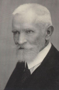
JENŐ CHOLNOKY
LAKE BALATON
(EXCERPT)
Its highest water level occurred approximately during the first great Ice Age, when it inundated the so-called *berkek* (marshy meadows) of Somogy County; the hill of Fonyód was an island, and the lake extended far to the south towards Nikla and Tótszentpál. Between Lelle and Boglár, and likewise at Földvár, the lake formed great bays reaching deep into Somogy. It also inundated the Tapolca Basin; the cluster of hills at Szigliget was an island, as was Szent György Hill. An enormous area around Kis-Balaton lay submerged, and even the lower valley of the Zala River stood under water, perhaps as far up as Zalaapáti.
(…)
Far gentler in character are the basaltic tuff mountains, among which Szigliget is particularly charming and remarkable.
The tuff mound upon which the castle ruins stand is somewhat more solid than the other two, in that its interior contains a vertical basaltic lava filling — or, as it is termed in scientific language, a dyke. This basalt dyke came into being when the hill cracked and basalt forced its way into the fissure, yet did not reach the surface but instead solidified below ground. In truth, the Szigliget group consists of three hillocks, the smallest of which bears the castle. Beneath it lies the village and the old manor house, in a setting of exquisite beauty.
Were the Balaton to rise very high, it would inundate the entire Tapolca Basin, up to the lowest houses of the town of Tapolca itself. Szent György Hill and the Szigliget hillock group would become islands, while between Gulács and Badacsony the low ridge would remain dry land, its erosion having been prevented by the Hármas-hegy — a basalt dyke now fully exposed by denudation. This sharp little ridge makes a most handsome sight.
In former times the Balaton kept this basin permanently flooded, but it has since been filled with alluvial deposits and loose silt. The road leading from Szigliget to Balatonederics crosses some nine drainage canals, naturally by means of bridges. These bridges gave the civil engineering authorities no end of trouble in earlier times, for they were perpetually sinking. Piling was attempted, but the piles slid away in the loose silt as though through butter. Today, after much backfilling and masonry work above, the bridges stand tolerably firm — provided no excessively heavy lorries venture across them, for these cause them to sink once more.
The meadows remain very waterlogged to this day and are difficult to traverse in wet weather. Before the war, magnificent rows of Lombardy poplars adorned the banks of the canals and the roadsides. From the hills, the view was splendid indeed — but alas, the dire shortage of timber during the war led to the felling of the greater part of them. (…)
In the region of Lake Balaton, all the basaltic eruptions took place at a time when but little water covered the Pannonian plateau, for the volcanoes first expelled fine rock dust which, falling into the water, gave rise to what is known as tuff. Only thereafter did the lava flow forth. The greatest lava flows occurred at Kab Hill and Agártető (…). Basalt caps the summits of our beautiful mountains — Badacsony, Szentgyörgy, Csobánc, Gulács, and many others. After the eruption of the basaltic volcanoes, the Pannonian plateau began to erode. When the terrain had been considerably worn down and the surface had come to resemble its present form, the Earth's interior made one final attempt — yet true volcanoes no longer stirred. Only quite minor eruptions disturbed the region. Accompanied by powerful steam explosions, the small volcanic vents hurled out rock dust, fragments of stone, and occasionally enormous boulders weighing hundreds of kilograms — yet no lava appeared. Lava did indeed rise, approaching close to the Earth's surface and solidifying within the crater of the small volcano, but it proved incapable of flowing out entirely. Volcanoes of this kind we term tuff-volcanoes. Such were the ones that made their presence felt at Tihany; the Szigliget hills are likewise of this origin, as is Várhegy at Boglár. True lava exists within the interior of Várhegy at Szigliget, and has also been found in the small hill of Hegyesd. These are, in general, situated at considerably lower elevations than the true basalt formations.
(Source: National Széchényi Library, Hungarian Electronic Library)
BADACSONY AND SZIGLIGET
Few landscapes in Hungary are as beautiful and singular as that which may be beheld from the hills of Meszesgyörök beside Lake Balaton, when one turns to look eastward, towards the region of Badacsony.
Lake Balaton offers, from virtually every point along its shores, a beautiful and varied prospect; the character of its banks differs greatly. The southern shore is, in general, a low, rolling countryside alternating with marshy, extensive plains, whose principal features are the dunes formed from coastal sand deposits and the peaty soil, across which herds of buffalo graze in scattered fashion. From these peat bogs rise, like islands, the castle hills of Fonyód and Boglár, both plunging steeply towards the lake. On the eastern section of the northern shore, the heights of the Veszprém plateau are visible — seen from the water, of course, as mountains, cleft by deep and narrow valleys. Towards the west, the edge of the plateau withdraws ever further from the shore, yielding place to a more articulated and varied highland which, at Révfülöp and Salfölde, extends right down to the lakeshore and encloses a large basin between Kővágóörs, Köveskálla, and Kisfalud. This enclosed basin has but a single, narrow outlet at Kisörs; from the north, access is barred by those basalt mountains whose most magnificent formations lie to the west of this region. For once the exceedingly steep south-western slope of the Örsi Hill — adorned with the picturesque ruins of a monastery — southwest of Salfölde has levelled out, a plain commences and extends westward as far as Ederics, and northward to the foot of Agártető. From this plain rise, in complete isolation from one another, the most perfectly formed basaltic volcanoes imaginable — among which the "wine-blessed" Badacsony holds, beyond all question, the foremost place. When the steamboat departing from Keszthely, having waded through the disagreeable beds of water-weeds, rounds the chapel of Szentmihály, there suddenly opens before one, in full splendour, the panorama of the basaltic volcanoes that form the backdrop to Szigliget Bay.
The foreground is formed by one of the hills in the Meszesgyörök area, with its sparse vegetation and rocky soil. Far, far to the east, the last lightnings of a retreating storm still flash intermittently; the lake remains dark and angry, heaving heavily in the wake of the tempest that has passed over it. Fearsome is the aspect of the lake at such moments. Beneath the dark storm-cloud the water receives no light, and with its wrathful green hue and the white wave-crests glittering upon it, it seems almost to boil before the daring soul who ventures upon it in a frail little boat. From the north, however, the sky is already clearing; the sun falls upon the waters of the bay, gilding the ruins of Szigliget and allowing the eye, through the air cleansed by the storm, to travel freely to the magnificent mountain group of the Badacsony region.
Most prominent is the sadly ruined castle of Szigliget; and beneath the castle, at the foot of the ruins, the tiny white cottages of Szigliget village gleam upon the hillside, as though smiling at the thought that they — mere mud-walled dwellings — have outlived the mighty eyrie towering above them. From the hill of the ruins towards the lake, several smaller hillocks are visible, clothed in woodland; at their eastern foot the Eger stream flows into the Balaton — having come a long way from below Tót-Vázsony — while from the west flows the warm water of the beautiful thermal spring of Tapolca. Behind these hillocks looms Badacsony, raising its rock-crowned truncated crown 332 metres above the lake. (Its highest point stands 438 metres above sea level, while the lake surface itself lies at a mere 106 metres.) Directly behind the ruins emerges the wondrously steep and pointed summit of Gulács (393 m above sea level). To the left, at the edge of the picture, Szent György Hill (415 m above sea level) obstructs the view of the only partially visible little Csobánc (370 m above sea level). Finally, between Csobánc and Szigliget, those likewise basaltic mountains that close off the above-mentioned Kővágóörs basin from the north show their blue outlines.
The counterpart of Gulács is Tóti Hill, that of Csobánc is Halyagos. To the north of Tapolca stands the handsome, regular Haláp (361 m above sea level), with the smaller Véndög to its west. Considerably further north of these, scattered at wide intervals, one finds yet more such basalt cones — among them Sümeg Castle Hill, Somlyó, Ságh, and Kissomlyó — which, though they belong geologically to the same region as the foregoing, no longer partake of that variety of landscape which the Badacsony region affords from any point of vantage. It must also be noted that the largest of the basalt volcanoes, Kab Hill and Agártető, do not possess such wondrous, scenically commanding forms as the smaller ones enumerated above. These rest upon highlands of different construction. The majestic forms of Kab Hill, like those of Agártető, are concealed by dense forest, and their vast bases imperceptibly merge into the surrounding hilly countryside.
The form of Badacsony and of the kindred mountains — Szent György, Csobánc, and Haláp (as well as the more distant Somlyó, Ságh, and Sümeg) — is that of a truncated cone. Up to a certain height their gentle slopes afford excellent soil for viticulture; above this height, nearly vertical basaltic cliffs rise abruptly, frequently cleaving in columnar fashion, as for example on Szent György. The summit of each is a small, flat plateau, upon which forest (Badacsony), pasture (Szent György), or perchance a castle ruin (Csobánc) finds a barely accessible refuge. The broad pedestal upon which the basalt columns rest, in the case of the lakeside mountains, consists of Pontian clay and sand, and it is the weathered product of this clay and sand, mixed with the crumbling detritus of the decaying basalt, that provides the excellent growing soil of the Badacsony vineyards. Badacsony is the most beloved excursion destination on the shores of Lake Balaton. The extensive hillside is dotted with hundreds of wine-cellars and summer villas, and the eye rests everywhere upon the fresh greenery of the most magnificently cultivated and carefully tended vineyards. A walk up to the hilltop will remain forever unforgettable to the lover of nature.
The path ascends beside a gully among summer villas, passing the house in which Sándor Kisfaludy spent the happiest days of his life. Before long the vineyards are left behind and the road enters the woodland nestling at the foot of the cliffs. The base of the cliffs is mantled with enormous boulder-flows on all sides, rendering the vertical basalt walls difficult of access. Through a small gap, by means of a natural and partly man-made mossy stairway, one reaches the top of the cliffs — and here the view opens wide. Upon the vertiginous precipice of the rock ledge, at the most splendid spot, stands a great stone cross, towards which the traveller who does not shrink from stepping to the dizzy edge clings with reeling head. A vast panorama of astounding variety unfolds before the eye. Over the enormous mirror of Lake Balaton, variegated by the play of the wind and the shadows of clouds, and over the low shores that wreath it, the view extends across great distances. From the glistening, marshy meadows rises the Vesuvius-shaped hill of Fonyód opposite; to its east, like a new island, the blunt castle hill of Boglár; and on the far horizon, the heights of Tihany shimmer. These three hills — Fonyód, Boglár, and Tihany — have this in common with the mountains of Badacsony, that the bulk of their mass likewise consists of Pontian clay and sand, yet their summits are capped not with basalt but with basaltic tuff — hardened volcanic ash or mud solidified into rock from mud volcanoes — and thus they lack that picturesque clustering of crags which so distinguishes Badacsony or Szent György. The circular plateau of Badacsony is fringed by the most fantastic groupings of rock. At the so-called Iron Gate, the stroller halts in wonder — surely human hands must have assembled those great stone colossi into towers, walls, and pyramids? On Szent György, the columnar basalt stands like a Brobdingnagian organ above the green clay chorus.
Towards the south, over a stretch where the ledge has subsided in a great notch-like depression, the local people liken it to an enormous armchair.
Of quite different character is the cone of Gulács. This is scarcely climbable: the basalt on its sides is weathered and crumbling, giving way underfoot, and on its summit — where in all likelihood few have ever set foot — there would hardly be room to erect a hut. Yet the view from here, too, is magnificent. The plain from which the hills rise is neatly chequered by the Lombardy poplars planted along ditches and roads, and the oases of the seemingly endless meadowland — the charming villages, each nestling at the foot of a volcano. Both in Szigliget Bay and at every wind-sheltered spot along the northern shore, dense reeds — the local people's *bozót* — cover the bank, making it impossible to determine the true shoreline. Beyond the reedbed, the water is covered with islands of water-weeds and bulrushes, and only when the depth gauge reads three metres does the surface of the lake become clear; here the vessels navigate, here the fishermen may ply their trade. Along the featureless southern shore, reeds are nowhere to be found; the strong northerly waves and the constant churning of the sand destroy them, and whatever these forces cannot eradicate, the ice finishes off. When the wind breaks up the lake's ice, it drives it almost invariably to the southern shore, the prevailing north-westerly current — which at times strengthens into a veritable gale — being the bather's disagreeable adversary. The drifting ice tears up the shoreline formations created the previous year and piles them in high ridges along the sandy coast. The northern shore generally escapes such ice invasions; it is a rarity for the southerly wind to gather sufficient force to break up the ice. Partly on account of this prevailing wind, and partly owing to the differing configuration of the shores, the character of the Somogy side differs entirely from that of the Zala side. Along the Zala shore the lake deepens abruptly to 1–2 metres, whereupon the bottom slopes very gradually. Along the southern shore, bathers must wade far out to find sufficient depth, but thereafter the drop to the maximum depth of 4–4.5 metres is all the more sudden. Only in the Tihany narrows, between Szántód and the Tihany ferry, is there a deep hollow reaching a maximum depth of 11 metres. In vain does one search for those depths of 40–45 metres proclaimed in old textbooks — they are nowhere to be found in our beautiful Balaton. Along the northern shore the lake bottom is silty, along the southern shore sandy, and this sand is well suited to the formation of recent coastal features: the waves build sandbanks (*Nehrung*) that close off the bays, behind which still marshes, peat bogs, and *berkek* come into being, and the formerly deeply indented shores of the ancient bays straighten out. At low water, the wind carries the sand from these sandbanks inland in the form of dunes, and thus, before the great enclosed former bays, a broad sandbank gradually takes shape. Along this sandbank runs the line of the Southern Railway from Felsőszemes all the way to Balatonkeresztúr. Along the northern, Zala shore, only traces of such formations are to be found; neither the material composing the shore nor the direction of the winds is suited to their development.
The remarkably picturesque Szigliget Bay receives one of the most significant groups of the streams that feed Lake Balaton; eight great channels carry the water here, of which four are permanently full: the Tapolca, washing the foot of Szigliget; the Lesence, flowing down beside Ederics, from which three villages have taken their prefix (Istvánd, Tomaj, and Németfalu); the Világos stream, connected to it at numerous points; and the Víszló brook, coming from far away, from the Nyirád forest. If we add to these the Eger stream, we find gathered here approximately one third of the total volume of the permanent watercourses flowing into the Balaton in this region. The greater part of all watercourses enters beneath the Fenék bridge, from the reedbeds of Kis-Balaton. This little primeval marsh — through which one can scarcely navigate elsewhere than along the artificially maintained channel of the Zala — receives the Zala itself, the Hévíz, the boundary ditch between Somogy and Zala, and the Csölömpes ditch. When the Zala is in flood, more water enters the lake through this single opening, beneath the Fenék bridge, than through all the other streams of the Balaton combined. A considerable volume also enters between Tihany and the north-eastern tip of the Balaton, through the valley gorges of the Veszprém plateau, where some ten streams issue forth from the ravines — yet even their combined flow does not match that of the Hévíz alone. In general, the volume of water that the Balaton annually receives from permanent watercourses is modest, while even less is discharged by its single outlet, the canalised Sió. The greater part of the inflowing waters leaves the lake by evaporation, as is evidenced by the fact that the water contains a higher concentration of dissolved salts than could be accounted for by the streams flowing into it.
But let us observe the Balaton after a storm. Only far on the horizon does a distant flash of lightning still intermittently glimmer: the wind has subsided, yet the lake still heaves. The vast body of water retains in its molecules the kinetic energy borrowed from the storm, and until this energy has been spent in the friction of the waves rolling one by one onto the shore, the surface of the lake will not be stilled. And after sunset, as the summer visitor — wearied by the heat of the day — sits on the veranda savouring the air refreshed by the storm, he hears with wonder that, though not a single leaf stirs on the hillside among the villas in the cool evening air, and though perfect calm reigns on the slopes of Badacsony, down below the lake roars, and by the golden bridge of the rising moon it is plain to see that it heaves strongly still.
Those who, never having witnessed the phenomenon with their own eyes, judged it only by the reports of laymen, declared that at such times volcanic activity — in the form of great gas eruptions (*endogenous hurricanes*) from the bed of the Balaton — was stirring up the water. In truth, however, it is nothing other than the continued oscillation of the water molecules set into rhythmic motion, persisting even after the agitating cause has ceased.
Still more singular is the phenomenon when a wind springs up over the lake while complete calm prevails on the hillside. At such moments too one may satisfy oneself of the illusory nature of the gas-eruption theory — for upon descending to the shore or rowing out a few kilometres, one will infallibly encounter the wind.
The volcanic world of the Balaton region was extinguished long ago. The lava that once flowed out upon the hilltops has since hardened into solid rock, into basalt; the mud volcanoes that erupted in more distant regions, and the ash scattered far and wide as volcanic bombs, have likewise solidified into stone. In Tihany, more than a hundred spouting hot springs (geysers) once shrouded the region in clouds of steam: of these, only the cooled and hardened calcareous tuff crater-cones remain. Of the whole volcanic past, nothing has survived but the charming warm springs of Hévíz and Tapolca.
Yet the traces of the great upheavals have not entirely vanished; the crags of Badacsony and Szent György still stand as their memorials. On Fonyód Hill, only a scattering of loose fragments bears witness to the tuff that once covered it; one steep side of Tihany slid into the Balaton in recent years. Just as the walls of Szigliget have crumbled, so, after many a thousand year, shall the basaltic crags of the volcanoes crumble away, and the unprotected clay base will be carved into its grave by the storms and torrents that sweep across it — and with it, perhaps, the beautiful Balaton itself, for the shallow basin may well be filled in a few thousand years by the sediment borne in by water and wind. The acrid smoke of factory chimneys sometimes settles over the horizon; the sky grows sombre and brownish; no sound rises but the ceaseless, uninterrupted murmur that bespeaks the life of the surging human multitude, while the great distances and the hazy air conceal the details — nothing is seen or heard of those dramas and tragedies that unfold in unbroken succession within the walls of human edifices; and the eye, wearied by the spectacle of the teeming life, rests with pleasure upon the wooded summits of the Buda hills, where the pure air and the azure of the sky seem to promise repose to the nerves exhausted by the tumult, the dust, and the clamour of the city.
(Source: National Széchényi Library, Hungarian Electronic Library)
(Jenő Cholnoky (1870–1950): geographer and university professor. One of the most distinguished figures
of Hungarian geography, born in Veszprém. From 1894 he worked at the Geographic Institute of the University.
He took part in the scientific research of Lake Balaton.)